Yampa River Management Plan
Yampa River Management Plan, 2003
The Yampa River Management Plan provides a framework to implement this vision. Below are excerpts from the Yampa River Management Plan. To read the full document, click on the link to download here: Yampa River Management Plan
Key Issues of the Management Plan:
- Recreation Use – “An inevitable result of continued population growth in and around Steamboat Springs will be more river users and more demand for this finite resource.”
- Land Use – “The YRMP should be compatible with other City plans and land use goals, and should address new development occurring adjacent to the river. “
- Aquatic Habitat – “As development in the study area continues, threats to water quality increase”
- Terrestrial Habitat – “The protection and enhancement of the natural environment along the river is a primary planning objective.”
Read More
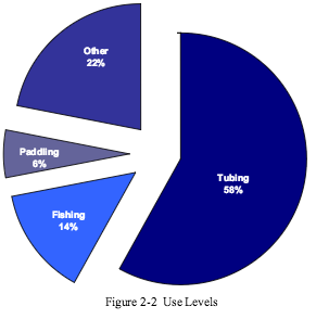
Commercial use on the river is predominantly tubing, followed by kayaking, rafting, fishing and canoeing. Commercial operators are required to pay 5% of gross revenues received from rental of flotation devices or other river recreation equipment to the City.
These user fees are designated by the Action Plan to fund the following:
- Stabilize river banks where degraded or presently eroding
- Provide educational signage at high-use locations
- Plant more trees along river and improve habitat
- Build more play features consistent with resource protection goals
Private users are not subject to all the guidelines outlined in Appendix B. However, private tubers are encouraged to follow the rules regarding etiquette, quiet zones, safety, litter control, etc.
A survey of Yampa River users was conducted June 18 through mid-September 2001. The two-page survey addressed user demographics, trip details and opinions. Surveys were conducted on random days of the week. A total of 1,136 usable surveys were collected.
Overall, the survey showed that visitors were “very satisfied” (78%) with their experience. Tubers tended to be slightly more satisfied than anglers. Most felt the quality of their experience was equivalent to their experience in previous years. Of those surveyed, most felt that recreational use has an adverse impact on vegetation, fish populations and water quality.
“It should be noted that surveying in 2001 did not begin until prime kayaking season was over so paddlers, most of whom are private users, may have been under-represented in the survey.”
 Is the Yampa River truly the last free-flowing river in the Colorado Basin?
“The hydrologic regime (timing and amounts of flow over the year) of many rivers in the west has been modified. These changes are typically caused by damming and diversion projects. The Yampa River and its major tributaries have relatively few dams and diversions from the headwaters to its confluence with the Green River. Reservoirs upstream of Steamboat Springs along the Yampa River include Yamcolo Reservoir, Stagecoach Reservoir and Lake Catamount, none of which are major storage facilities.
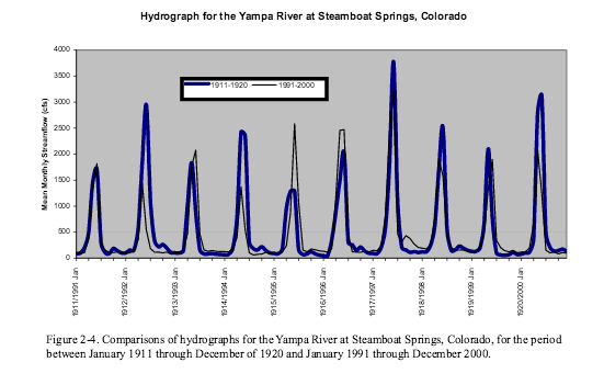
Based on a review of historic flows of the Yampa River at the Steamboat Springs U.S. Geological Survey (USGS) gauge station, the flow regime seen in the early 1900’s appears to be relatively similar to those seen in the present day. Therefore, many of the physical forces of the river that influence plant and animal communities in the past continue today. Figure 2-4 compares recent versus historic hydrographs, showing that the flow regimes are very similar. During both periods, peak spring flows tended to range from 2000 to 3000 cfs.”
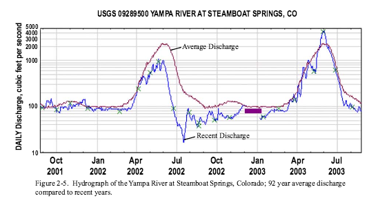
“Additionally, a hydrograph (Figure 2-5) for the period from August 2001 through August 2003 is presented to show the effects of the drought year of 2002 on Yampa flows. Flows in July of 2002 were below 20 cfs for a short period and below 80 cfs for a good part of the summer and fall. Conversely, a wetter than normal winter resulted in 2003 spring runoff flows that exceeded 4,000 cfs.”
The Five River Management Areas:
- Walton Creek This upper reach is the most undeveloped reach in the study area and it has the highest level of natural and aesthetic qualities. This RMA begins approximately ½ mile below the parking lot at Chuck Lewis State Wildlife Area
- Fish Creek This RMA is located between Fetcher and Weiss Park and contains a mix of land uses.
- Snake Island This RMA is a relatively short section approximately 0.5 miles long. The downstream limit of the reach is Weiss Park.
- Downtown The RMA is located in downtown Steamboat Springs and extends from the vicinity of the Howelsen Ice Arena downstream to the 13th Street Bridge.
- Stockbridge This RMA is located between 13th Street and the James Brown Soul Center of the Universe Bridge.
Implementation
“The Action Plan is intended to provide a framework for implementation and management actions needed to attain the plan’s vision. It is also designed to give decision-makers a useful tool for establishing future work programs and budgets. The Action Plan addresses the question: “What do we need to do to make sure the plan is successful?” The intent of the Action Plan is to stay simple — allowing users to obtain a “big picture” reference point and an indication of priority actions for the future. Since funding and other variables will change, this Action Plan will be periodically amended.”
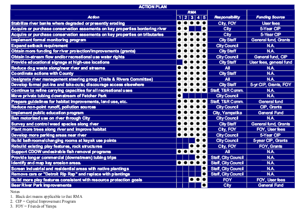
Note: User Fees are the 5% that the City collects from river outfitters for these projects.
Management
The overall management framework is presented as a series of principles and policies, organized by the following categories:
- Recreation
- Land Use
- Aquatic Habitat
- Terrestrial Habitat
A formal monitoring plan should be funded to ensure the continuity of data collection and address the following basic river characteristics:
- Water quality
- Aquatic diversity
- Terrestrial habitat
- Recreational experience
- Adjacent land use
Principle, Recreation: Manage resources for public use while protecting the natural values of the river.
Policies:
- RE-1. The Yampa River should be managed in a manner that preserves a range of recreational opportunities.
- RE-2. Provide a range of recreational activities that are compatible with the natural environment. Allowable uses are:
- Trail Use
- Swimming
- Watchable Wildlife/Educational Features
- Tubing
- Fishing
- Kayaking
- Canoeing
- Rafting
- RE-3. Recreational uses should be distributed in a manner that ensures a high quality recreational experience and protects the natural environment.
- RE-4. Provide appropriate river access.
- RE-5. Recreational uses should be managed at sustainable levels that preserve a high quality recreational experience and protect the natural environment.
- RE-6. Specific recreational uses on the Yampa River should be managed in a manner that supports the vision and planning objectives
Commercial river companies will adhere to the guidelines outlined in Appendix C. Users of the river should also follow best management practices on the river, including:
- No glass allowed
- No littering
- No Styrofoam coolers
- Respect other river users (i.e. fisherman, kayakers, waders, etc.)
- Respect private property
- Dogs allowed per leash laws
- No alcohol
- Avoid standing or walking on river bed (except fishermen)
- Life jackets, floatation devices and proper footwear recommended
- No bathing or diapers in river
Principle, Land Use: Recreational uses should be managed in a manner compatible with adjacent land uses.
Policies:
- LU-1. Recreational users should adhere to the two quiet zones and other regulations in order to reduce conflicts with adjacent property owners.
- LU-2. Access points are a primary management tool for the river.
- LU-3. A limited amount of on-river signage will be added to the river corridor to support management activities and goals.
- LU-4. Remaining elements of the core river train should be constructed in an environmentally friendly manner.
Principle, Aquatic Habitat: Aquatic habitat should be improved and enhanced.
Policies:
- AH-1. Fish habitat management will be coordinated with the Colorado Division of Wildlife (CDOW).
- AH-2. Aquatic habitat will be improved to enhance fisheries.
- AH-3. Protection of the aquatic habitat and trout fishery should be the highest priority. If one or more resource protection triggers are met, the Yampa River may be closed to certain recreational users, based on consultation with CDOW staff. Triggers include:
- Water temperatures exceeding 75 degrees F for two or more consecutive days,
- Dissolved oxygen levels average less than 6.0mg/l,
- Flows less than 85 cfs.
- AH-4. Maintain or improve the existing water quality for fisheries, aesthetics and other ecological considerations.
- AH-5. Preserve existing stream flows.
- AH-6. Consider obtaining other water supplies.
- AH-7. Provide greater protection of the River through more restrictive floodplain regulations.
- AH-8. Enforce stormwater management regulations.
Principle, Terrestrial Habitat: Terrestrial habitat should be improved and enhanced.
Policies:
- TH-1. Provide large contiguous areas adjacent to the river, free of human disturbance.
- TH-2. Additional open lands and natural areas should be protected.
- TH-3. Manage vegetation to protect and enhance the natural habitat of the river, placing special emphasis on protecting native riparian and wetland vegetation.
- TH-4. Provide buffers from development to protect terrestrial and aquatic resources.
- TH-5. Encourage non-regulatory approaches.
- TH-6. Remove invasive vegetation.